A Critical
Review of My Practice
James Hankey
|
| I
have always been interested in the ocean and coastlines,
and one of the main reasons I came down to study in Cornwall was
because the county has five hundred miles of coastline. Part of my
fascination with coastlines comes from living near Lyme Regis.
Also, I have acknowledged that coastlines are the most
natural (untouched by man) landscapes there are (1). This
really intrigues me as you can see marks that natural processes alone
have made.
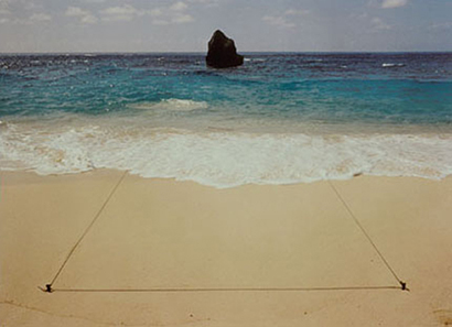
After looking at artists like John Pfahl
and his ‘Altered landscapes’ series, I had preconceived ideas about
what I could do. I really enjoyed the way Pfahl’s images played with
perspective. He created (seemingly) two dimensional shapes in a three
dimensional space, - for example Bermuda Triangle, Bermuda (Fig 1).
|
|
|
 |
|
|
These images are great because they show that the artist has a genuine
awareness of his surroundings and of the characteristics of the land.
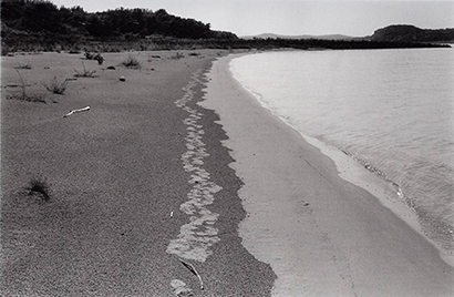
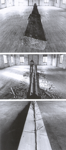
At the same time I was looking at the
work of artists such as Richard Long and Hamish Fulton. Their art
work revolves around the process of walking. They use walking as a way
to get closer (physically and psychologically) to nature and their
artwork aims to promote an awareness and appreciation of nature. Fig
2 is an example of Richard Long’s work that I found very interesting
as he was repeating and almost re-emphasising marks left by a natural
occurrence – the tide. |
|
|
 |
|
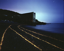
| I
knew that that I could create similar images (i.e. line drawings in a
space) using long exposures (10 minutes to 2 hours) at night and
moving around the frame with a lit torch (influenced by Thomas
Flechtner’s book entitled ‘Snow’). I produced a few images that were
reflective of Long’s work. |
|
|
 |
 |
|
|
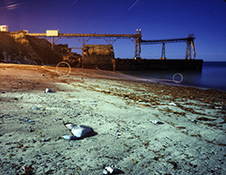
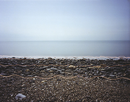
Whilst looking at the images from these shoots I realised how
important site-specificity was. I had made marks on the photographic
film by highlighting seaweed left by the tide or emulating how erosion
can change the location of a particle on a beach; with the intention
of promoting an awareness of natural processes. I realised though,
that these areas that I was photographing were not the best examples
of places where obvious natural occurrences occur i.e. erosion
from waves or long shore drift.(2) I wanted to return to my
home town - Lyme Regis because it is constantly changing due to
landslides and there are many good examples of long shore drift
(3) in the area. One of the images I am most pleased with is the
image below of Chesil beach. |
|
|
 |
|
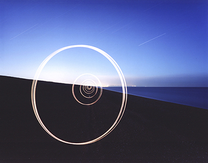
| I
feel it works compositionally and has an element of intrigue but more
importantly is one of the most site specific images I have produced.
Any shape repeated inside it-self would draw the eye into the image,
but I wanted to use a circle because the shape has symbolic
significance with infinity and cycle, which is reflective of how the
17mile long beach or spit (4)(longest spit in Europe) was
made.
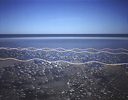
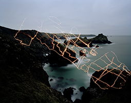
The image below (Fig 6) is a long exposure of the incoming tide on a
sand bar near Charmouth beach and the light lines are me walking in
the frame holding a lit torch.
|
|
|
 |
 |
|
| I
produced a series of work on coastlines using this technique of
walking back and forth. I became aware and fascinated with the work
of Chris Drury when he presented his work at a R.A.N.E lecture
(Research in Art, Nature and Environment) at Woodlane. I really like
the way his work uncovers and makes relationships between patterns
that naturally occur on very different scales (i.e. weather patterns
and heart cross sections). When I looked at my work, I recognised that
the marks made by the torch (held at a point on my body) had a direct
relationship to the ground I was walking on – the flatter the ground
the more uniform the frequency and amplitude of the line and visa
versa (Fig 7). The pattern made by the light (in Fig 6) is suggestive
of the ripples in the sand and also the motion of a wave. The pattern
reminded me of A-level physics – when we had to plot sine graphs or
simple-harmonic-motion graphs. This pattern is inherent in many
natural occurrences – wave motion (whether sound, light, water or
electromagnetic) as well as correlating with circular motion, which in
this case can indicate the circular trajectory of the moon around
Earth – creating tidal changes. I
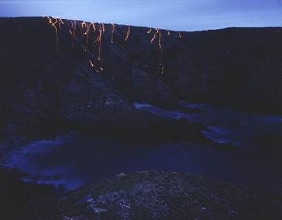
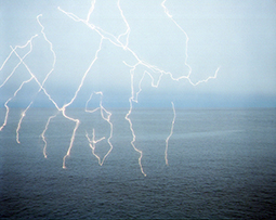
produced a series of work on southwest facing cliff tops. I used lit
newspaper to record the traces of the prevailing/predominant
south–westerly winds and also to emulate cliff erosion. This work was
the start of the adrenaline inducing and slightly silly (in terms of
safety) work, that later was to become quite important. For this work
I would wait until it got dark, start the exposure and proceed to walk
(with no torch!) onto and around cliff top edges (that could be 20
minutes walk away), - and set alight newspaper to let the wind take
the paper on its due course. Either that or I would wrap (in news
paper) loose stones found at the cliff top edge, light them and roll
them down the cliff letting gravity and the contours of the cliff
compose the marks (reflective of the process that produces boulders at
the base of these cliffs). Observing the unpredictable movement of the
burning paper was really rewarding and almost meditative, despite the
fact that one slip in the wrong direction and I wouldn’t be here
writing this! |
|
|
 |
|
It was at this point I realised that I needed to research more into
the physical characteristics and geological significance of specific
parts of the Cornish coastline. I started by referring to geology
text books, which informed me how specific
rock formations were formed, where fault lines were situated, and what
terms like ‘dyke, zawn, and upright tight synclines’(6) (!)
referred to. Consulting a geological map, I
marked on my Lizard O.S. map where different types of rock lay next to
each other on the coast. Out of curiosity I wanted to see if I could
find exact locations of where these rocks met. The results were
mixed, but on the whole I found that these locations were always
intriguing in terms of the physical attributes of the land –
protruding rocks, caves and zawns were often present, even quarries -
Porthoustock.An important
influence is the Arte Povera movement of the late 1960’s early 70’s.
The artists that were and are most appealing to me are Giuseppe Penone
and Giovanni Anselmo. In the work entitled ‘Tree’, along with many
other works of this nature, - Penone reveals the tree that is latent
in the common form of a plank of wood. Penone uses photographs to
reveal a ‘process in reverse’ from the plank growing into the tree. I
really liked the way Penone reveals natural forms in a functional
material that is usually accepted for its face appearance.
|
|
|
 |
|
| The
more I read and explored, the more I understood about the significance
of rock type in conjunction with its geographical situation (whether
the site is prone to wave erosion etc), - in the formation of the
physical appearance of the place. I experimented with double
exposures to try to create a visual interpretation of this. Below
(Fig 10) is an example of this, - a photograph that was taken facing
south-east towards Kynance Cove. |
|
|
 |
 |
|
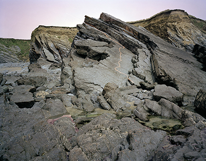
| Fig 10 'Tremolite
serpentine and Kynance' |
|
|
This image seemed busy in its composition and I originally questioned
the necessity for a long exposure. Fig 11 is the result. This image is
interesting, and something I didn’t initially intend. The pattern of
the boulder’s surface draws visual similarities with lightning, and
also the patterns of maps; - perhaps reflective of the journey the
rock took to get to its present location(7). I experimented
with other locations but found it difficult to find rocks that had
clearly definable lines of weakness.
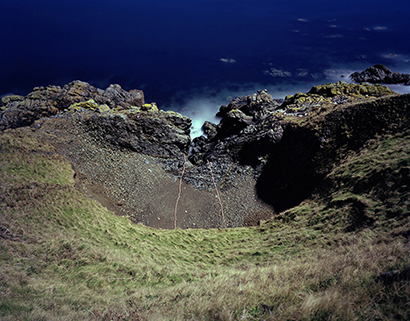
I also used double exposures as a way of
revealing the necessity of camera position in showing a natural
process. Fig 12 is a photograph of a landslide with the cross section
of that landslide exposed on top of it; - almost to make the viewer
aware of the coefficient of friction (or angle) needed to create the
landslide. |
|
|
 |
|
|
Although I really liked the daylight image, I recognised that I was
extremely fortunate to come across a recent landslide in Cornwall,
opposed to West Dorset – an area that I come from and whom Jem Southam
repeatedly visited and documented landslides. I also became conscious
that the images that worked really well were the long exposures where
it was obvious I had moved within the frame. (Example - Fig 13) |
|
|
 |
|
| The
ability of a long exposure (in moonlight- effectively reflected
sunlight) to record colours that are close to, yet sometimes very
different from daylight, even though the human eye only picks up
hardly distinguishable hues of colour, really adds excitement and
anticipation to the outcome of the image. This, - combined with having
to walk to the locations and climb on the rocks themselves (which, as
I have already mentioned previously, can be and normally is adrenaline
inducing) is really important to the overall image making process.
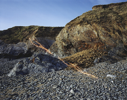
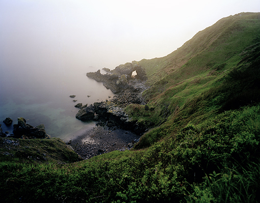
In the photograph on the next page for
example (Fig 14), I had to traverse down the entire ridge of the cliff
(in the dark) to reach the arch at the centre of the frame. I had to
work out (by observing the waves and rock formations below) where the
start of the opening to the arch began, so I could make a similar
light line that would reflect the obvious weakness in the other (left)
side of the arch. |
|
|
 |
|
| I
hope that the peculiarity of the image and image making process will
invoke questions in the viewer. Questions’ that are perhaps similar to
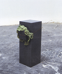
that which Giovanni Anselmo’s work asks. Anselmo’s ‘Untitled, Eating
Structure’ 1968 for example, makes the audience visually deconstruct
the process of the decomposition of the lettuce and its affect on the
structure of the sculpture. The smaller granite block falls out when
the lettuce decomposes. |
|
|
 |
|
| The
images that work most successfully have a balance between function -
in informing the viewer of what has or might happen; and ambiguity -
in provoking a question of how and why the image was made. For example
– Fig 16 below |
|
|
 |
|
| |
|
(1)In the UK it would be
difficult to point out any stretch of land -no matter how natural
in appearance, that hadn’t been shaped somehow (directly or
indirectly) by man. Coastlines are the exception, with the
relentless force of the ocean, the shape of the coast constantly
changes at various rates.
|
|
(2) Although every coastline
erodes, all have different rates of erosion and because of the
geology of Cornwall, its coastline erodes very little compared to
other coastlines i.e. West Dorset/ East Devon and therefore it is
a bad example.
(3) Long shore drift is
where beach matter travels along the coastline in the direction of
the dominant or prevailing swell.
|
|
(4)A ‘spit’ is a narrow and
long stretch of sand/shingle that extends out to sea, or partway
across a river estuary caused
by the process of long shore drift.
|
|
(5) At different locations
on The Lizard you will find all six layers of the oceanic crust,
many different types of rocks including rocks that are usually
10km below the surface (bastite serpentine). You will also find
many examples of dykes, fault lines, zawns, caves, blow holes,
arches, stacks, as well as very rare plant and animal life.
(6) A ‘dyke’ is a protrusion
of rock sandwiched between another type of rock, formed when magma
under pressure finds weaknesses in the spreading axis of the more
solid crust of rock above.
A ‘zawn’ comes from the Cornish dialect for chasm. Basically it is
a weakness in a rock, which over time has been eroded by wave
action – often forming perpendicular lines if rock or possibly
small coves.
‘Upright tight syncline’ just describes the shape of layers of
rock that have folded under heat and pressure from colliding land
masses.
|
|
(7) In the severe cold of
the last ice age, “ice penetrated the fissures (cracks) in the
cliffs above, then expanded and cracked off huge blocks. When the
hard ground thawed into mud, the cracked off crusairs (gabbro
boulders) tobogganed down from the tors” to there present
locations amongst bastite serpentine. Extract from ‘Beneath the
Skin of The Lizard’ 2000 pg 26
|
|
(8) Turner presented the
work on an island only accessible at high tide, encouraging the
audience to understand the subject of the work –the moon and its
influence on the tides. – Something that is quite difficult to do
in photography.
|
|